Emergency Incident Detection from Crowdsourced Waze Data Using Bayesian Information Fusion
A principled Bayesian framework that fuses noisy, redundant crowdsourced Waze reports across space and time to detect and localize traffic accidents. On Nashville data it beats count/reliability baselines in F1 and AUC, and on average flags accidents 5.92 minutes before the official record.
Emergency services learn of crashes late, through 911
Fusing unreliable, displaced, redundant crowd reports into calibrated incident probabilities
Problem
Emergency services are reactive: they wait for 911 calls. Crowdsourced platforms like Waze offer a proactive signal, but reports are unreliable (variable user credibility), spatio-temporally uncertain (people report after driving past), and redundant (many reports per incident; Fig. 1). Prior work used simple aggregation (counts or averages) of surface features with no principled treatment of uncertainty, and did not analyze the effect of spatio-temporal resolution.
Framing: humans act as unreliable sensors and accidents act as faults, which makes this an analogue of fault diagnostics in cyber-physical systems.
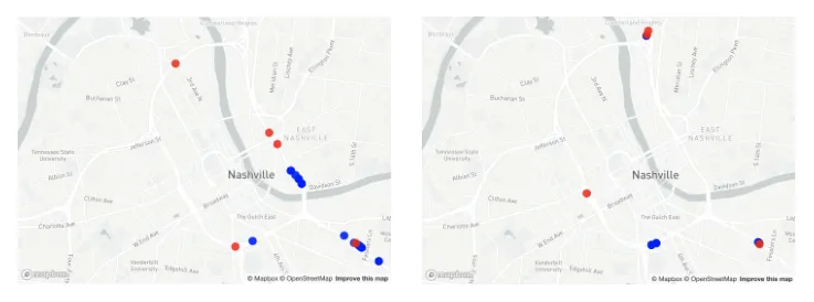 Fig. 1: Waze reports (blue) vs. actual incidents (red) in the same region at two different times, which shows the fusion challenge.Figure from Senarath et al., IEEE/WIC/ACM WI-IAT 2020.
Approach
- Spatio-temporal discretization: H3 hexagonal grid regions; fixed time steps (Fig. 3).
- Grouping reports to incidents: segmentation (collect all reports in a region over the incident period) vs. DBSCAN clustering on location and time (best ε = 0.8, silhouette 0.8156).
- Incident detection: Naive Bayes posterior P(incident | reports), treating each report’s reliability/10 as its true-positive probability; priors from historical E-TRIMS counts per region and hour (Eqs. 2–5).
- Incident localization: each report covers a circle of radius δ = v·t_r (reporter speed × reaction time); the likelihood is proportional to its area overlap with each region (Eqs. 6–8).
- Sequential updating: the posterior at step m becomes the prior at m+1; new reports join existing clusters or start new ones (Sec. IV-G).
- Alert decision: logistic regression / random forest learns the probability threshold against E-TRIMS ground truth (Sec. IV-H).
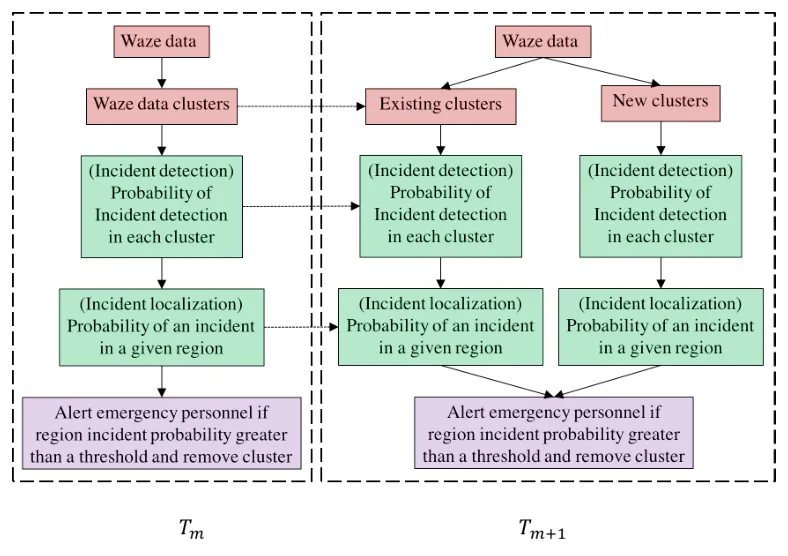 Fig. 3: Pipeline across time steps T_m → T_m+1. Red boxes are data and clustering, green are detection and localization, purple is the alert decision.Figure from Senarath et al., IEEE/WIC/ACM WI-IAT 2020.
Key results
- Evaluation: 5-fold CV; Oct–Dec 2019; 33,218 Waze reports, 2,878 E-TRIMS incidents.
- Best hyperparameters: incident period T′ = 25 min, time step = 1 min, δ = 100 m, H3 resolution 6.
- Best F1: 48% (M6, segmentation-based plausibility + logistic regression) vs. 45% for the best baseline (M2). Best AUC: 71% (M7/M8, all features, clustering) vs. 65% baseline (Table II).
- The conclusion reports a relative F1 gain of over 5% against baselines.
- Clustering gives higher precision but lower recall; the random-forest baseline has the highest recall (78%) but low precision.
- Early detection: the best model (M6) flags accidents on average 5.92 min before the official E-TRIMS record. In the case study (Fig. 8), Waze reports arrive 12 min before the official record.
Contributions
- A novel Bayesian-theoretic method for spatio-temporal fusion of noisy crowdsourced reports, with uncertainty quantified as calibrated probabilities (confidence per prediction).
- Sequential updating of incident probabilities as new reports arrive (real-time).
- Analysis of how spatio-temporal resolution affects detection.
- An extensible framework for other noisy crowdsourced sources.
Limitations & future work
- Matching crowdsourced reports to formal records is hard because of human error and reporting delays.
- Assumes constant reporter speed and independent reports.
- Future work: automated feature extraction and fusion; road-segment fidelity instead of regional grids.
Cite this paper
Senarath, Y., Nannapaneni, S., Purohit, H., Dubey, A. (2020). Emergency Incident Detection from Crowdsourced Waze Data Using Bayesian Information Fusion. 2020 IEEE/WIC/ACM International Joint Conference on Web Intelligence and Intelligent Agent Technology (WI-IAT), 187–194.
@inproceedings{Senarath2020b,
  author       = {Senarath, Yasas and Nannapaneni, Saideep and Purohit, Hemant and Dubey, Abhishek},
  booktitle    = {2020 IEEE/WIC/ACM International Joint Conference on Web Intelligence and Intelligent Agent Technology (WI-IAT)},
  title        = {Emergency Incident Detection from Crowdsourced Waze Data Using Bayesian Information Fusion},
  year         = {2020},
  organization = {IEEE},
  pages        = {187--194},
  keywords     = {Conference,first,Crowdsourced},
  url          = {https://ieeexplore.ieee.org/document/9457694/}
}